Our house
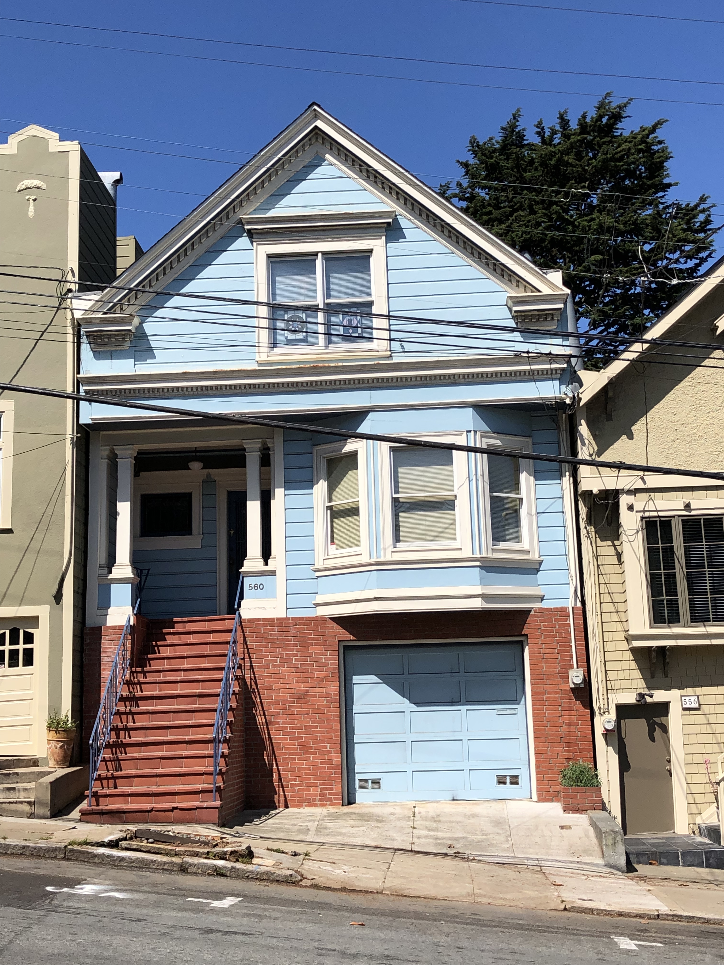
We are very fortunate to live in a wonderful house (560 29th Street) in a city we love (San Francisco). This page gives some history of the house (just called "560" below) and its residents based on 2017-2018 online detective work (details here), starting from very helpful San Francisco Public Library online resources and census records. Only three families have lived in 560 in its 110 year history: Nichols 1908-1923, Sichel/Richardson 1924-1979, and Ness 1980-present.
My Upper Noe page contains photographs of our neighborhood from 1890 (when the block across the street was the Mitchell dairy) to present.
This page is dedicated to George Nichols (at right; see below). I'm sorry he did not live to enjoy a long and happy life with his wife and kids at 560.
Click on any image to view full resolution version, then use the back button on your browser to return.
Parcel maps
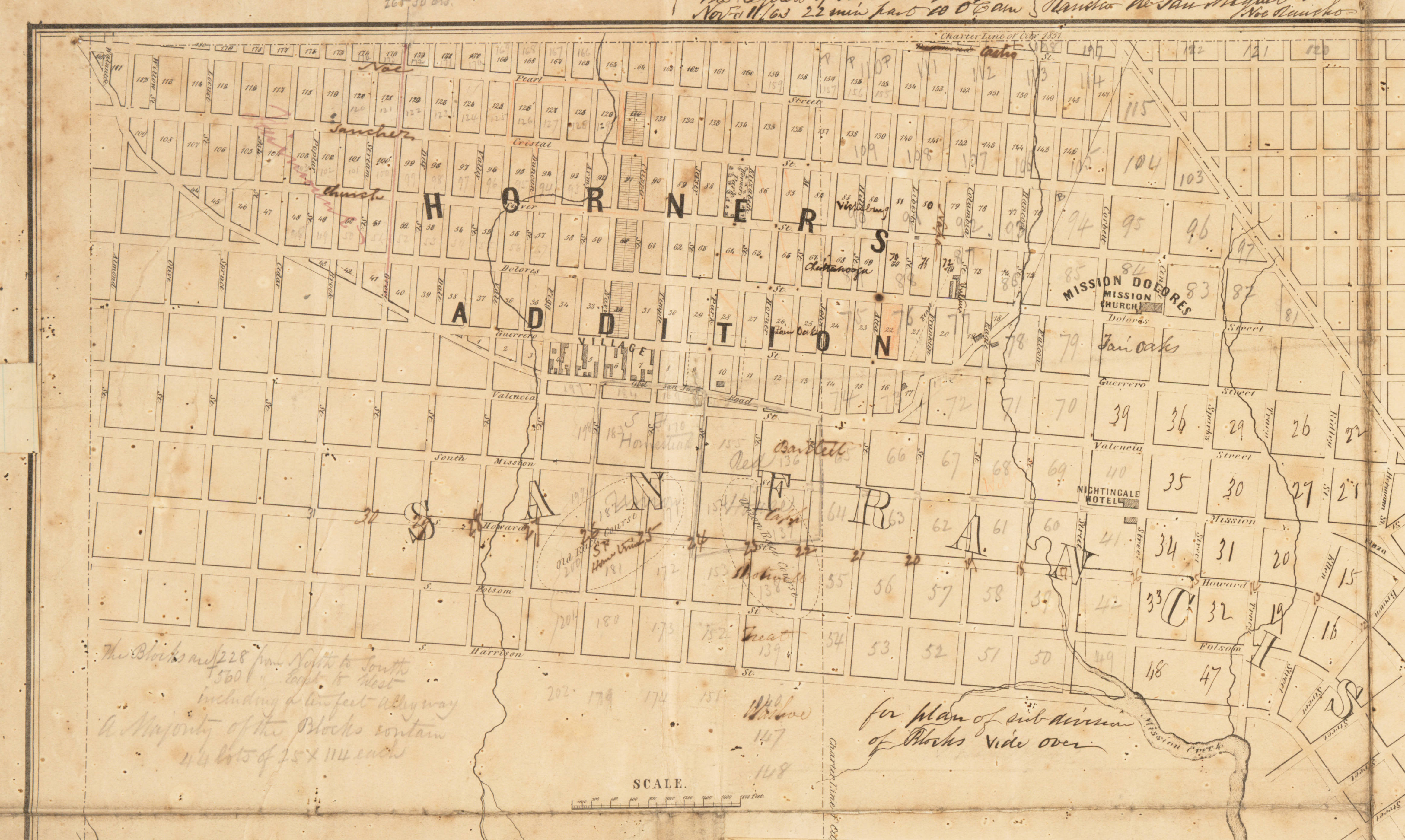
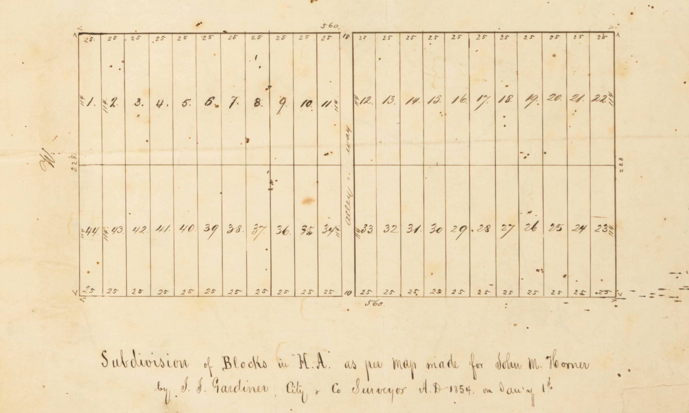
José Noé receives a large land grant Rancho San Miguel in 1845 (before the Gold Rush) and sells part of it to John Meirs Horner in 1853 (soon after the Gold Rush). Horner plats the land into rectangular blocks and lots, intending to develop it as a residential San Francisco suburb called Horner's Addition on a fascinating 1854 map. Horner's Addition includes most of present-day Noe Valley. The street layout on this map is theoretical rather than actual, but large portions correspond to the present, although only some of Horner's street names survive. Our city block is Horner's Addition block 170 (Castro/Valley/Noe/29th now, Diamond/Valley/Pearl/Dale on the map). Above: the Horner's Addition portion of the 1854 map (west at top), an inset showing proposed subdivision of a generic 560'x228' block into 44 25'x114' lots, and the eastern part of block 170 (at the western edge of the map, so shown only in part).
Because of the hilly terrain, remote location, and economic issues, actual development over the ensuing decades is very slow, especially on very steep hills. Bird's-eye-view lithographs of San Francisco by G.H. Goddard in 1868 and 1876 show the early development of Noe Valley. These detailed views look east across Upper Noe toward Mission Street (top left to middle right). The 1876 view shows the Italian Hospital (middle toward the bottom).
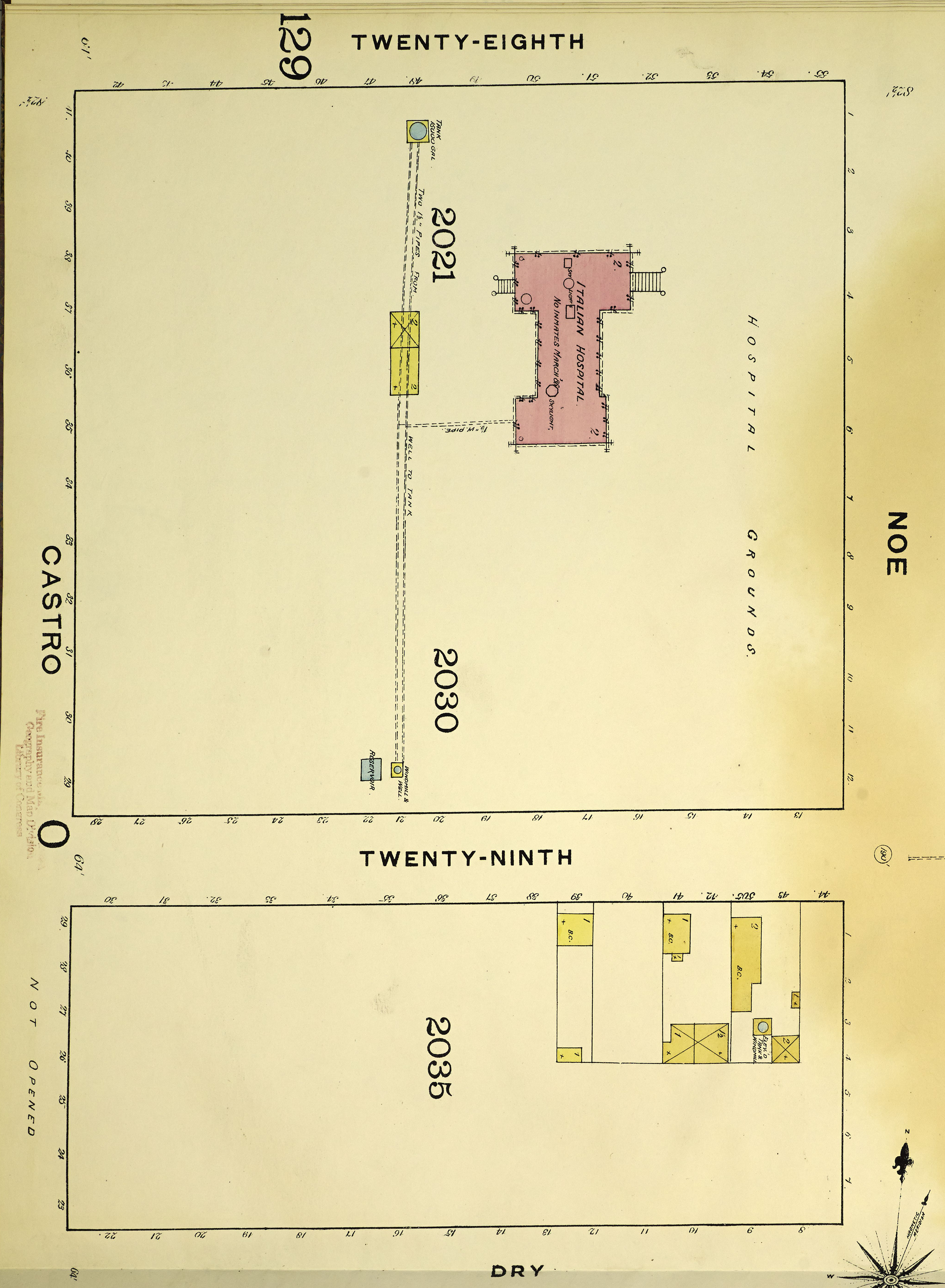
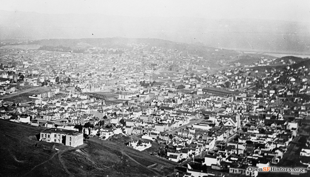
The 1886 Sanborn insurance map shows Valley does not yet exist west of Noe, the large block 29th/Noe/28th/Castro is occupied solely by the Italian Hospital (ca. 1869-1905), and the Mitchell dairy is the sole occupant of the Day/Noe/29th/Castro block. (Flatter blocks of Upper Noe are more developed.) The hospital's water supply is a well and windmill at what is now 556 29th, with a reservoir at 560 and a pipeline running up the steep hill to a water tank near 28th. The 1890s photo from Red Rock Hill shows the Italian Hospital foreground left; the site of our house would be just below the bottom of the frame.

The size of block 170 remains unchanged today from the 1854 Horner map. In 1901, Hibernia Savings and Loan Society owns all of block 170 except for two lots at the 29th/Noe corner. Our hilly block slopes down from NW to SE, from the Castro/Valley corner (upper left, elevation 310') to the 29th/Noe corner (lower right, elevation 200'). Not surprisingly, lots at the bottom of the hill sell first. Today (in 2021) the parcel layout is modified from the generic 1854 proposal: the useless 10' alley in the middle of the block is removed and some lots along the north/south streets are rotated 90 degrees. This requires tweaking of some lot sizes, though most lots are still 25'x114'.
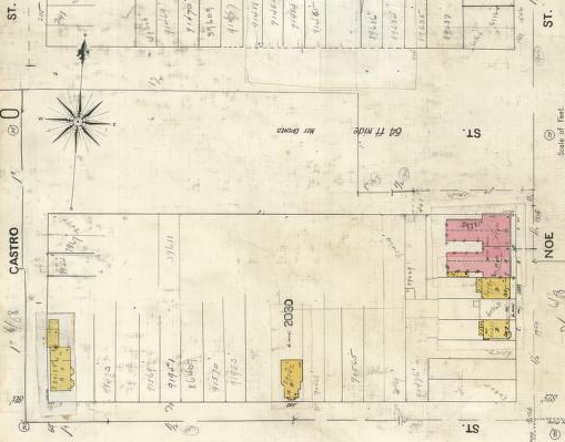
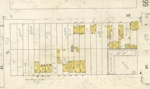
The 1905 Sanborn insurance map shows five buildings on the block, three on Noe and two on 29th (at 546 and 590). 590 at Castro/29th was destroyed by fire, possibly arson, in 1911 (San Francisco Chronicle 04/23/1911). 546 remains as the oldest house on this block of 29th, now with a second story added in 1989. Valley is largely ungraded (noted as "not opened") above Noe. As seen at right, the south side of 29th has more buildings, many related to the Mitchell dairy.
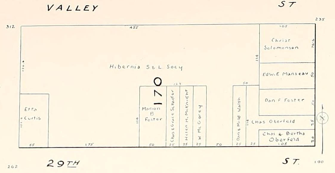
The block develops rapidly between 1905 and 1910. In 1906 (the year of the great earthquake and fire), Hibernia still owns about half of the block, including 560, but all the lots along Noe and some lots along 29th are subdivided. Several buyers purchase double or triple lots. Marion B. Foster's double (now single lots at 550/552 and 556) is just east of 560.
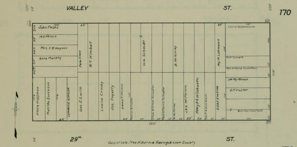
By 1909, after the quake, all lot divisions are drawn in and most lots have owners. Emma T. Nichols owns our lot (560), and her uphill neighbor (564) is Jos. Fogarty. The San Francisco Property Information Map database incorrectly lists 560 as built in 1900; the original building permit issued on 10/07/1907, so it was built during the great post-quake building boom (more details under Nichols family below).
The 1914 Sanborn map shows all of Noe and almost all of both sides of 29th filled in. As the 1915 photo below shows, Castro just north of 29th is partially blocked by an 8' high rock bank; it blocked Castro completely before the 1908 neighborhood project described below.


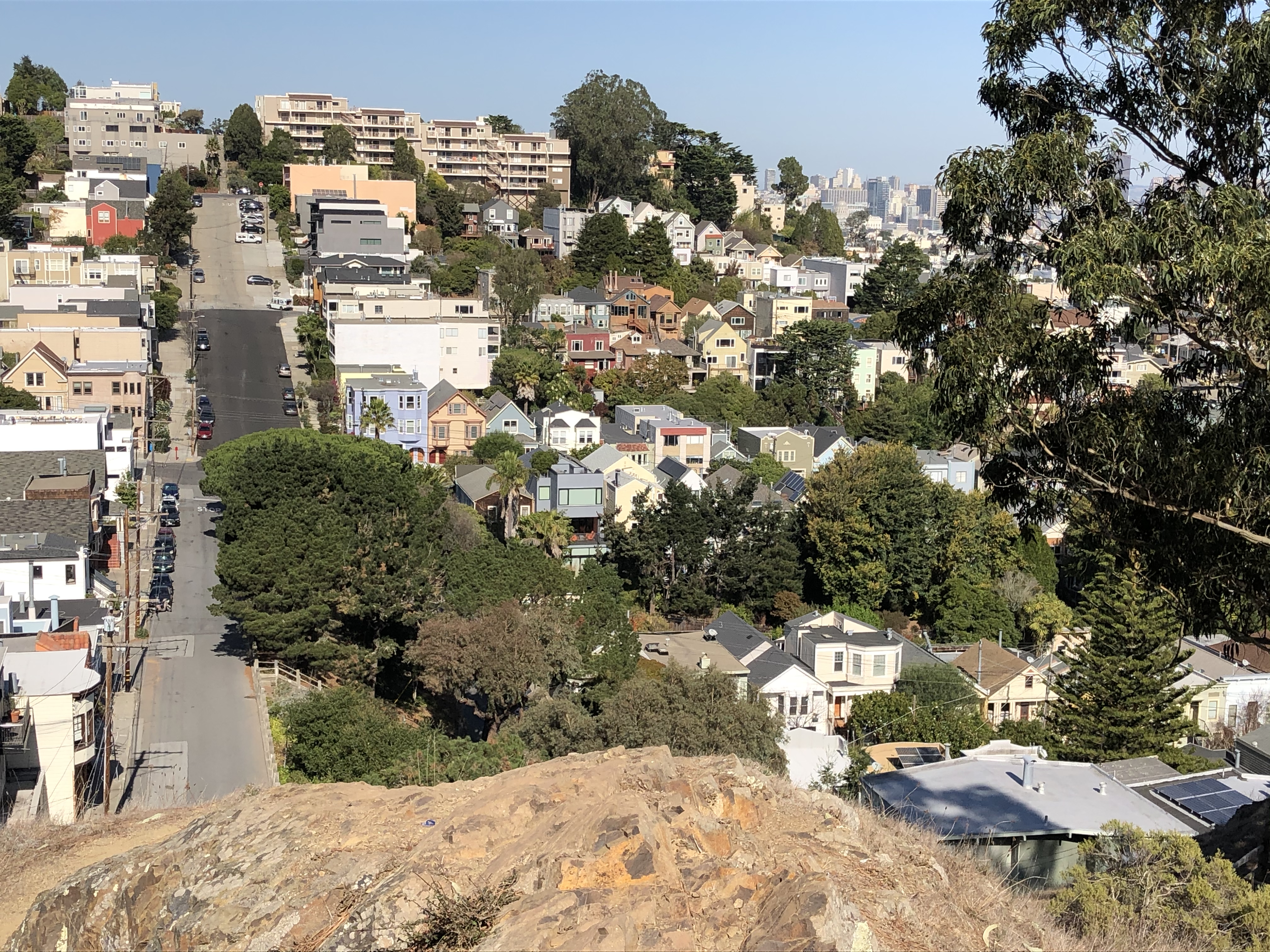
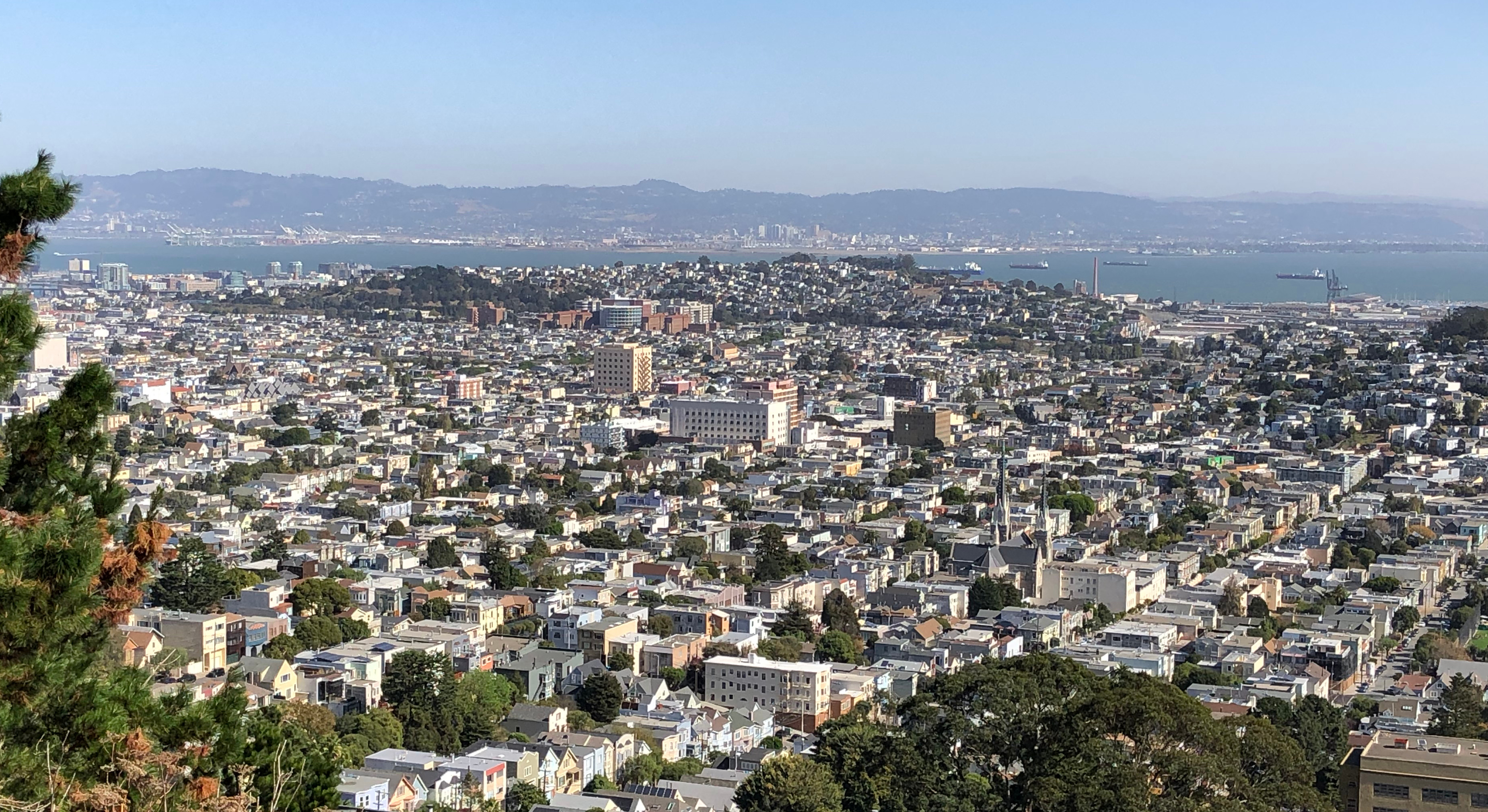
This 1915 view north from Billy Goat Hill at 30th/Castro is the earliest photo I've found of our house (detail center). Castro is at left, with (bottom to top) Day/29th/Valley/28th running horizontally. A century later, in 2019: almost all of the houses in the 1915 photo still stand, Castro is graded and paved, trees obscure much of the view.

The 2017 assessor's parcel map (block 6621) shows only four parcel modifications over the 108 years since 1909: double at 556 subdivided, two at 29th/Noe rewhacked to three, triple at Noe/Valley subdivided, three on Castro merged. Three lots have become two-parcel condos since 2003. This map says "Horner's Add. Blk 171" while the earlier maps say 170, presumably a clerical error. Our house is on lot 17.
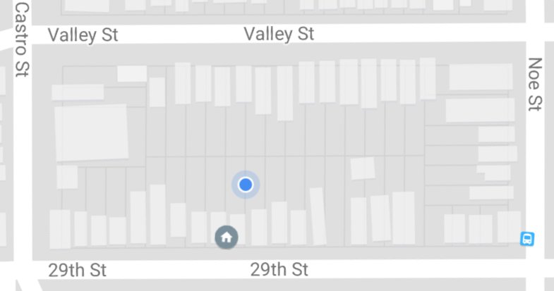
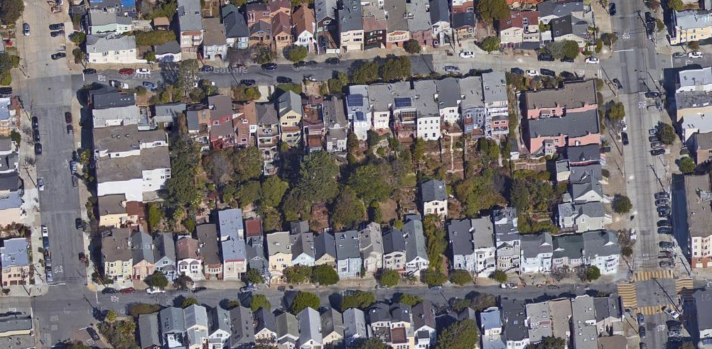

Here's a 2017 Google Maps image of the block with buildings shaded in, the corresponding satellite view, and a zoomed-in satellite view of our house. Google knows everything, of course: the house icon identifies our house (roughly) and the blue dot is where Google thinks I'm sitting as I write this (close but not quite).
The Nichols family
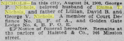
George F. Nichols (b. June 1859 in CA) marries Emma T. Nichols (b. 1/23/1863 in NY) ca. 1885. The 1880 census and the 1891 Langley Directory identify George as a carpenter, then the 1898 directory lists him as a special policeman. Emma and George live at 425 Banks (in Bernal Heights) from 1892. They have three children, all born in California: Lillian (b. Oct. 1887), David (b. 2/18/1893), and George (b. 12/01/1897). In 1900, they own their house in Bernal free and clear (i.e., without a mortgage).
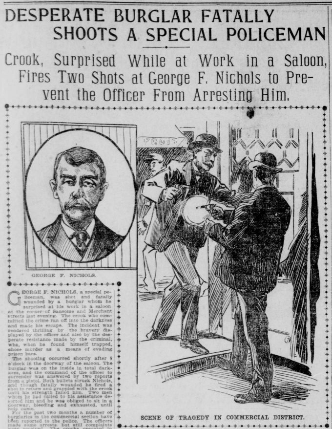
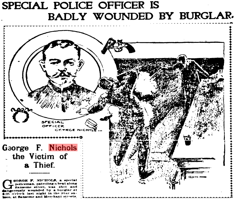
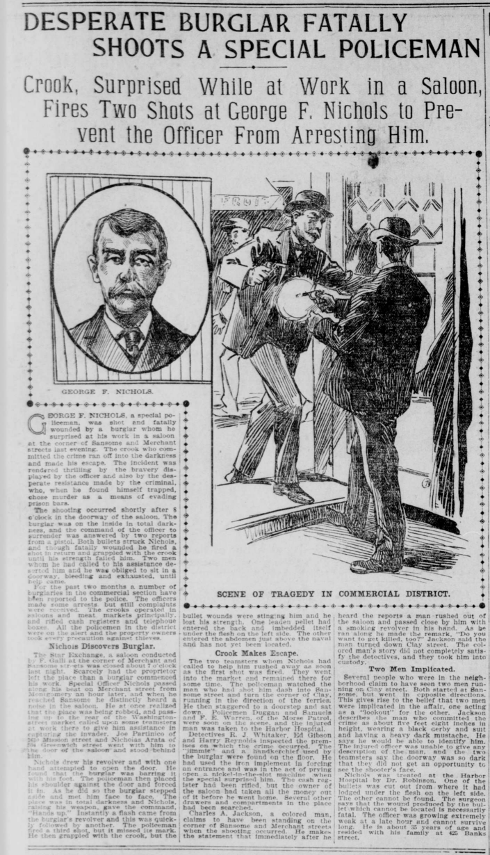
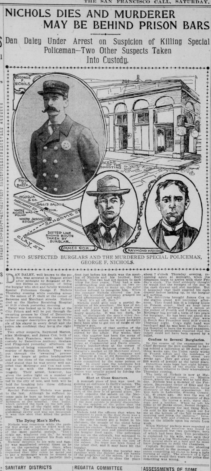
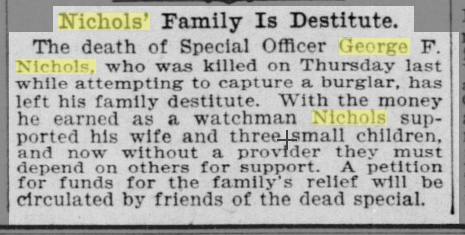
Special policeman George Nichols is shot on 8/23/1900 during his investigation of a burglary in progress and dies the following day, as reported in the San Francisco Call (08/24/1900, 08/25/1900, 08/25/1900) and the Chronicle (08/24/1900). The Call of 08/28/1900 says his family is destitute after his death, and ten days later the Chronicle of 09/08/1900 reports that a woman is posing as Emma to collect aid.


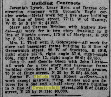
The Crocker Langley Directory for 1900 lists George at 425 Banks, but the 1901 edition instead lists Mrs. Emma T. at the same address, and subsequent years through 1907 list her as a widow. Whether through benevolence or the sale of their home on Banks, Emma has sufficient resources to build a new house during the 1907 post-quake building boom. The Call of 10/06/1907 lists her building contract with Robert McEwen to build a one and a half story frame house for $3000 ("one and a half" rather than "two" because the second story had a slightly smaller footprint than the first due to the roof slope). The Spring Valley Water Company connected water at 560 on 12/05/1907, and the 1908 directory lists Emma at the newly built house at 560 29th.
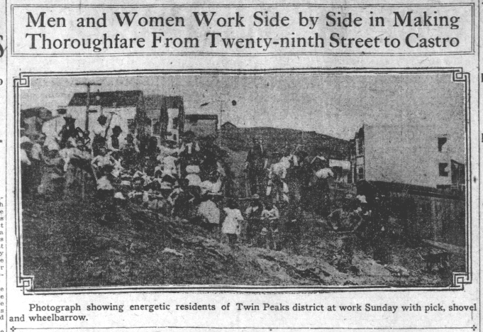

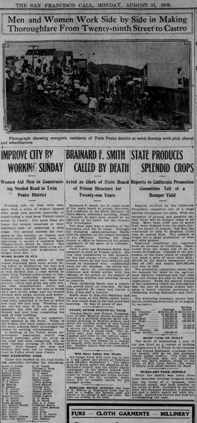
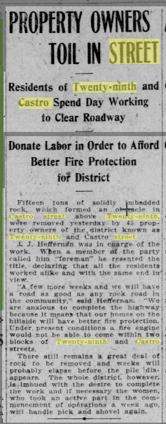
Call articles on 08/31/1908 and 09/14/1908 describe a neighborhood road clearing project at 29th/Castro, listing Emma among the workers. The 1914 Sanborn map shows a large "bank 8' high" still obstructing much of Castro just north of 29th.
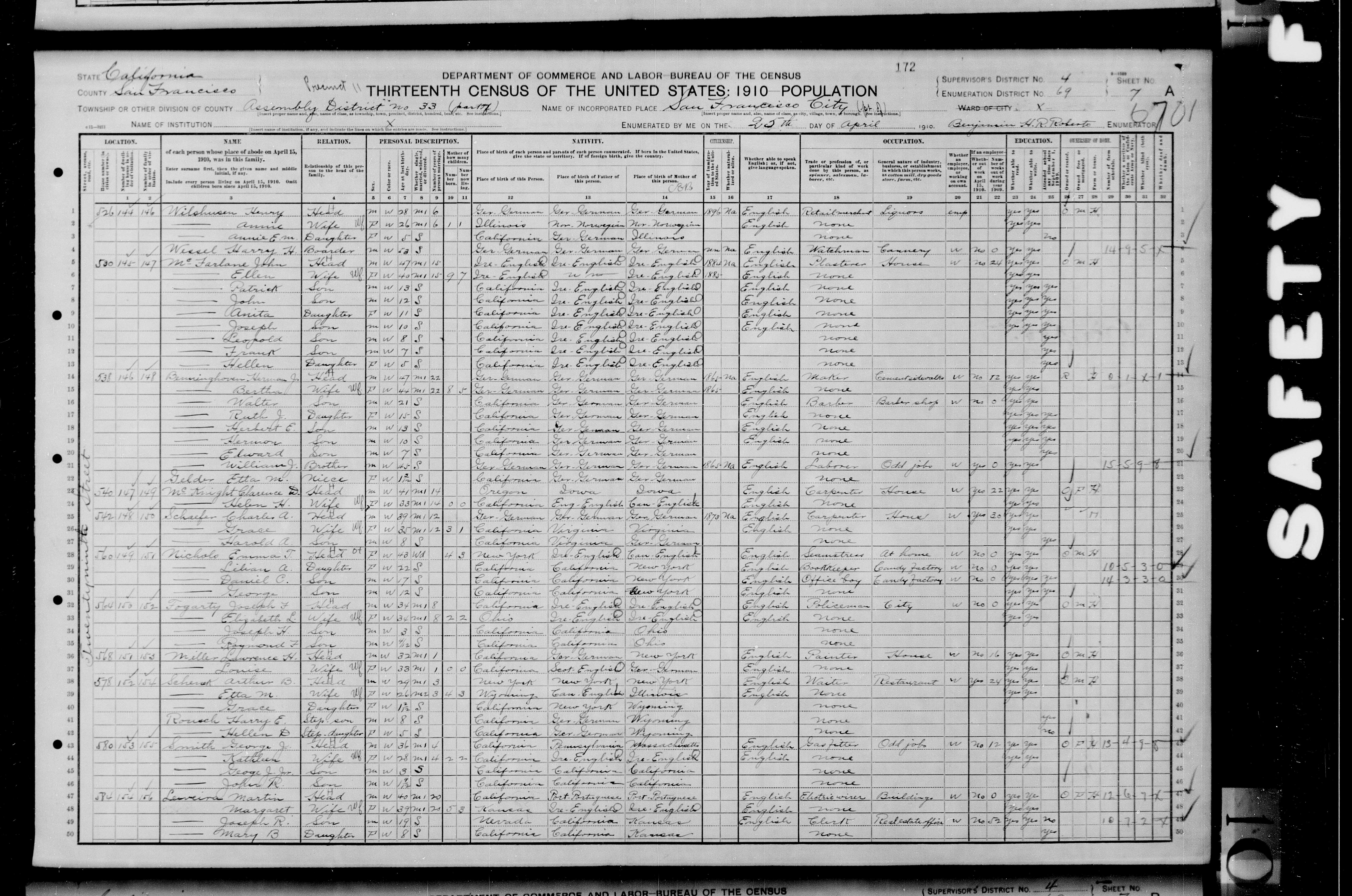
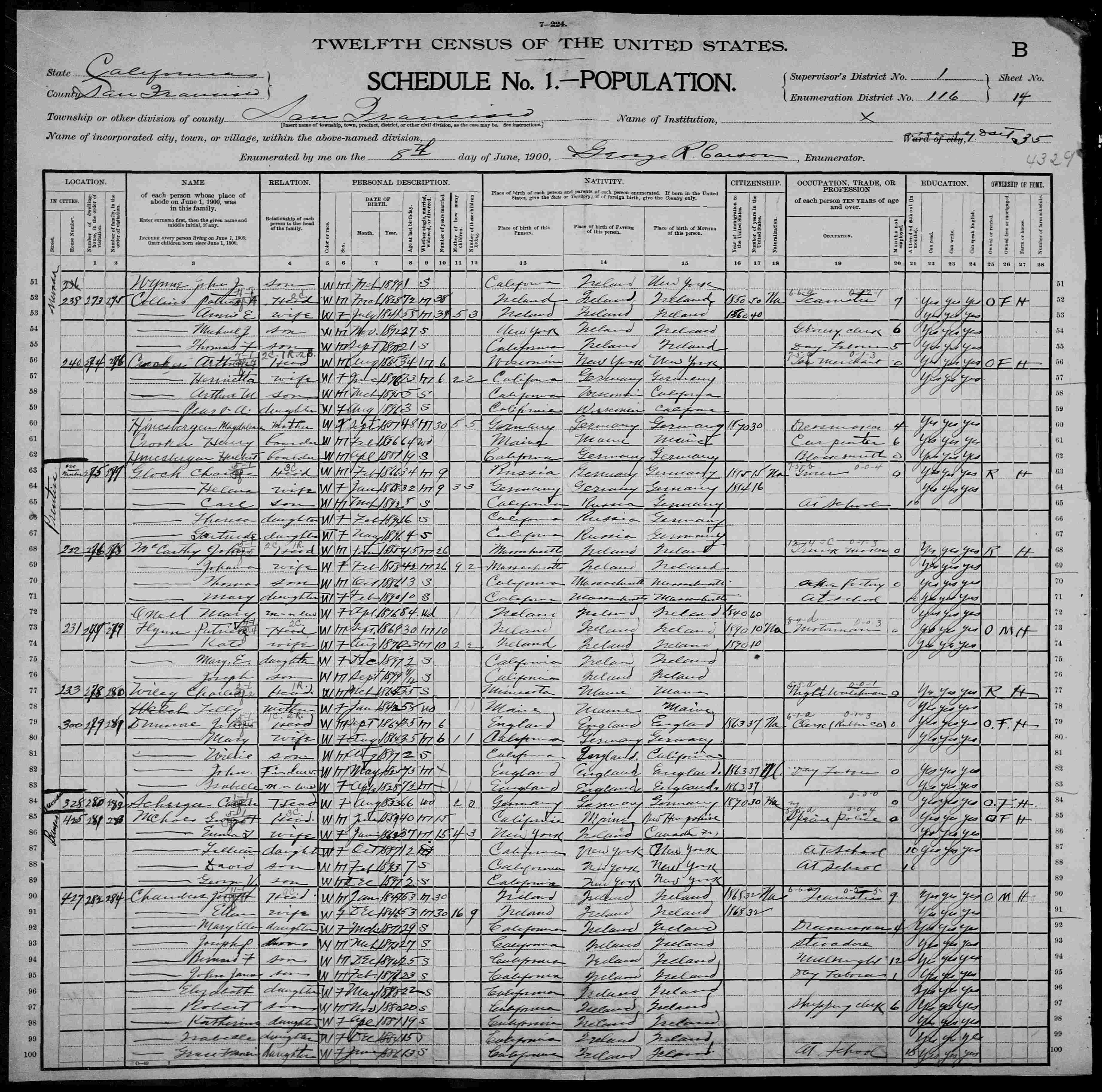
In 1910, Emma lives at 560 with her three children (ages 22/17/12) and owns the house (mortgaged). She's a seamstress, working at home, and the two older kids work at a candy factory. Her next door neighbor at 564 is policeman Jos. Fogarty. Perhaps he knew special policeman George Sr. before George's death.
In 1920, Emma still lives at 560 (now listed as owned free) with her three children (bookkeeper, confectioner, furniture salesman) and their white bull terrier Spike (Chronicle 01/19/1920). The census record gives the family name incorrectly as Nicholls, not Nichols.
Emma and her children remain at 560 in the 1923 city directory. In the 1924 edition, Emma lives on 7th Avenue with David and Lillian, so she presumably sells 560 in 1923 or 1924. The Nichols family lived at 560 for 15 years (1908 through 1923). Emma dies in 1956, David in 1970, and George Jr. in 1983, all in San Francisco.
The Sichel/Richardson family
San Francisco native Arthur Sichel (b. 5/24/1868) is the son of German immigrants Max Sichel (b. Baden ca. 1825) and Fanny Sichel (b. Baden ca. 1835). His dentist father first appears in San Francisco in the 1860 Langley Directory. In 1880, Arthur lives with his parents, 4 brothers, 4 sisters, 1 brother-in-law, 1 nephew, and a servant at 722 Filbert (full house, 14 in all).
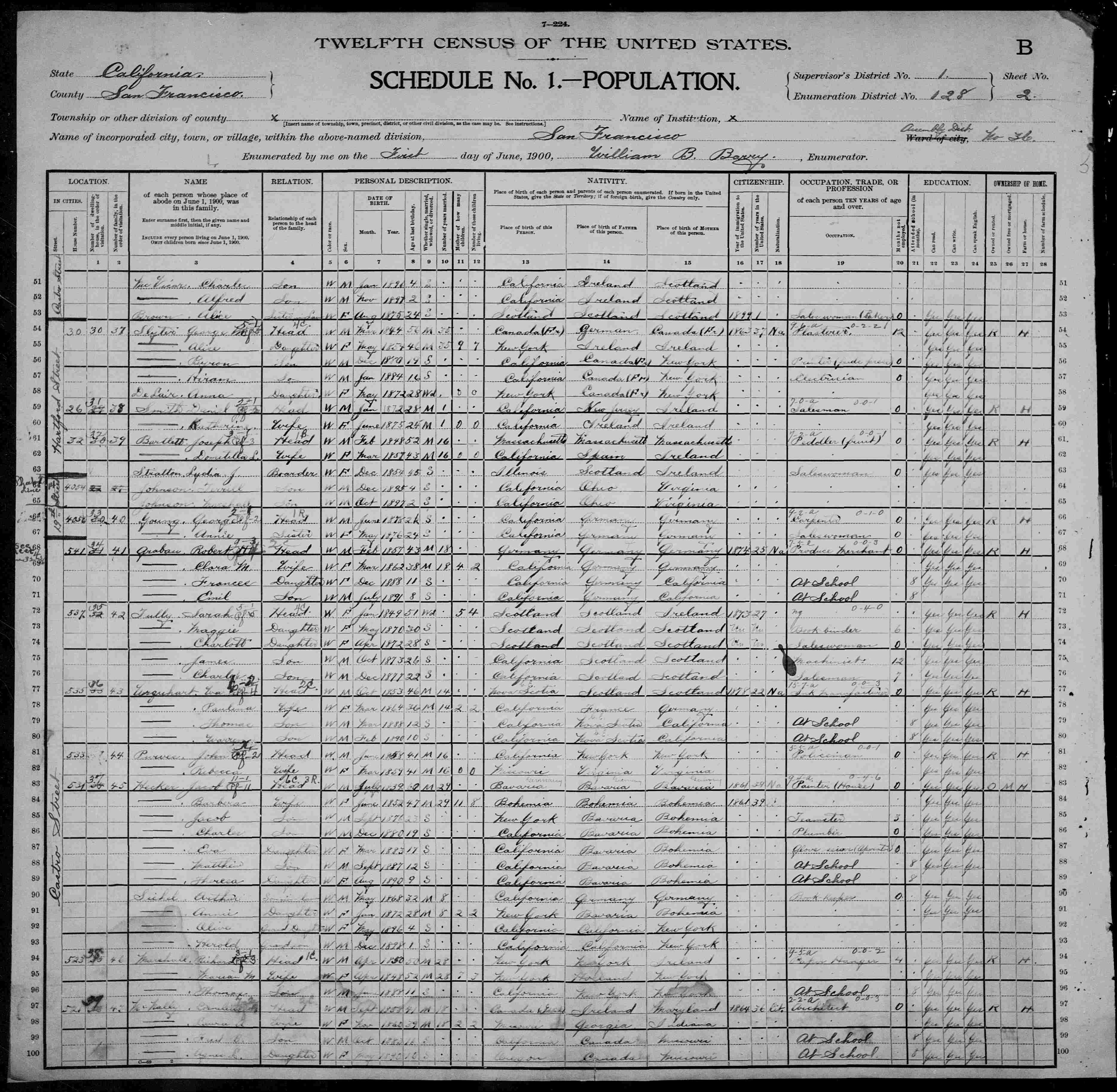
Annie (or Anna) Sichel (née Hecker, b. NY 1/15/1872) is the eldest child of German immigrants Jacob Hecker (b. Bavaria July 1839, d. SF 7/16/1905) and Barbera Hecker (b. Bohemia June 1852), married ca. 1871. Though born in NY, Annie lived in San Francisco by the time she was 9. She marries Arthur Sichel ca. 1892. They have five children, all born in California (probably in San Francisco): Olive Frances, b. 5/02/1896; Harold, b. ca. 1899; Maxine, b. ca. 1901; Lawrence, b. 1/18/1902; and William, b. ca. 1906. In 1900, Arthur and Annie live at 531 Castro (between 18th/19th) with Annie's parents, five of her younger siblings (ages 24/20/17/13/10), and their first two children (ages 4/1) — another full house, 11 residents in all! The 1900 Crocker-Langley Directory gives the occupations of Annie's father, two brothers, and husband: Jacob Hecker (stableman for Eggers & Co.), Jacob Hecker Jr. (peddler), Charles Hecker (plumber for W. C. Forsyth), and Arthur Sichel (bookkeeper for C. D. Laring, listed at his work address 2230 1/2 Mission).
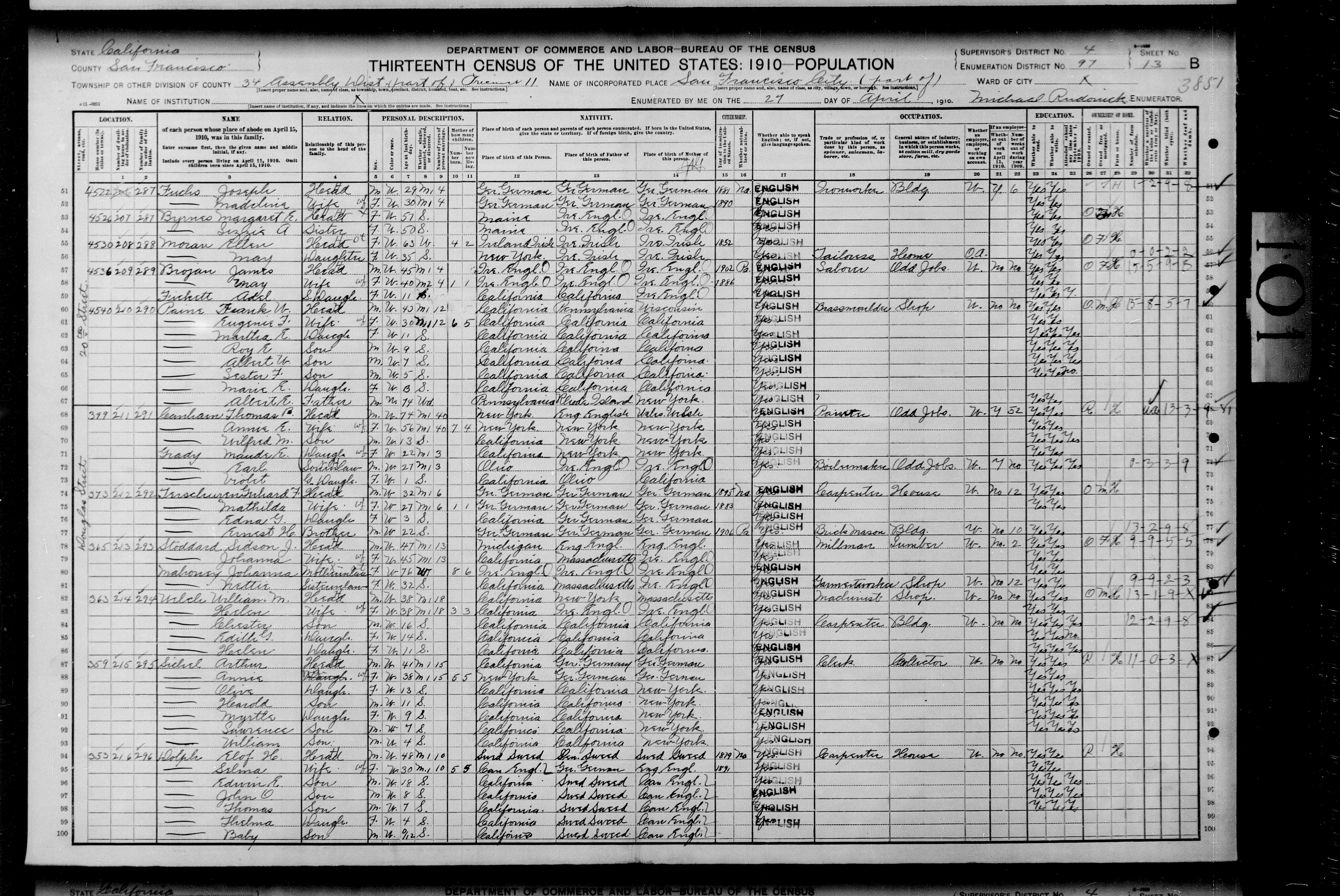
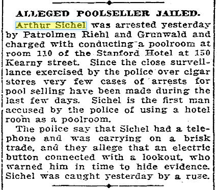
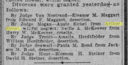
The 1905 city directory lists Annie's brother Matthew Hecker (clerk for Bancroft-Whitney Co.) still at 531 Castro, but Arthur Sichel (clerk for S Kullmann) and his family have moved down the block to 511c Castro. The 1909 directory lists bookkeeper Arthur residing at 4435 19th Street. In the 1910 census, Arthur and Annie live with their five children at 359 Douglass. The census record misidentifies Maxine as Myrtle. Arthur and Annie apparently have some marital difficulties: the Chronicle of 02/14/1909 lists Arthur's arrest for running a gambling operation and the Call of 02/22/1911 lists their granted divorce on the grounds of willful neglect. But they reconcile quickly, as the Call for 11/07/1911 reports their (re)marriage license issued.
Olive marries salesman J. Gordon Richardson ca. 1918. She lives with her husband and two infant girls at 230 Douglass in 1920, but they will soon move to the East Bay.
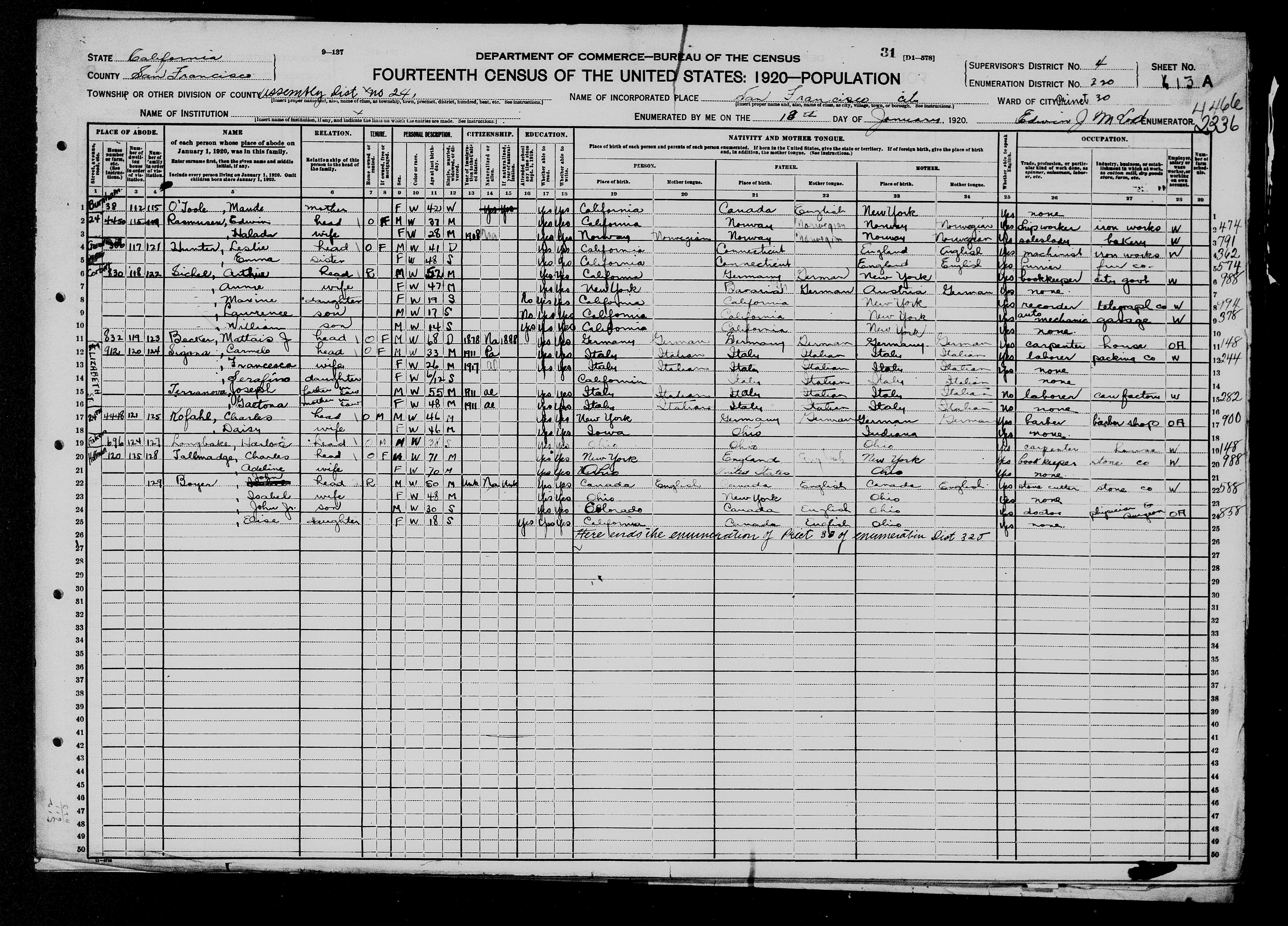
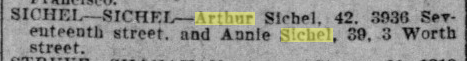
In 1920, Arthur and Annie live with their three youngest children Maxine/Lawrence/William at 830 Corbett.
In 1930 Olive lives in Berkeley with her daughters but not with J. Gordon. The census lists her as married (not divorced or widowed) and head of household.
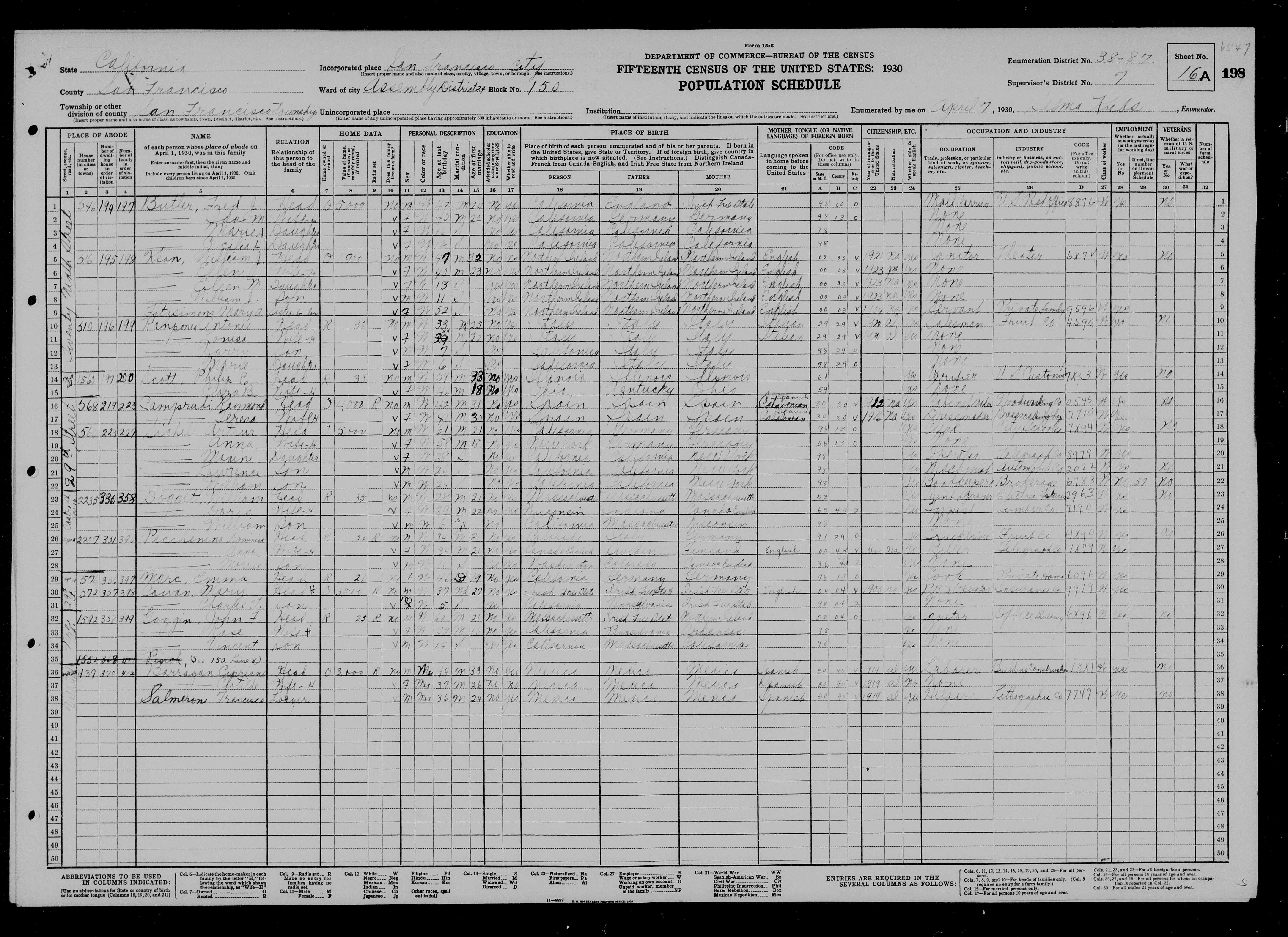
The Sichels buy 560 from Emma Nichols in 1923 or 1924. The 1924 Crocker Langley Directory lists Maxine (bookkeeper) at 560, then 1925 lists Arthur (machinist), Lawrence (laborer), and Wm. H (clerk, Wells Fargo Bank and Union Trust Co.) at 560. In 1930, Arthur and Annie live at 560 (valued at $5000) with their three youngest children Maxine/Lawrence/William (then 28/26/24). Lawrence is an automotive machinist, which explains some artifacts in our garage (oily residue on workbench, metal strap on beam for attaching a winch).
The 1933 city directory lists Arthur (laborer), wife Annie, Lawrence (auto mechanic), and William (musician) at 560. The 1934 edition lists widow Olive Richardson back with her parents at 560. In 1940, Arthur and Annie live at 560 with Olive and Lawrence. Maxine and William have moved out. The 1940 census record lists Olive as divorced, not widowed, and the online census database incorrectly transcribes Sichel as Sechel and Lawre as Laurel.

Arthur and Annie still live at 560 with Olive and Lawrence in the 1950 census.
Arthur dies 11/26/1950 and Annie dies 1/09/1962, both in San Francisco. Olive and Lawrence continue to live at 560 after the death of their parents. The 1948-1949 Polk Crocker Langley Directory lists Olive Richardson as a telegraph operator for Western Union, promoted to supervisor in the 1955-1956 edition (now Polk's Directory), living with brother Lawrence Sichel. She still lives at 560 in the 1978 edition. Olive lived at 560 for at least 44 years (1934 through 1978), and her parents lived at 560 for at least 9 more years before that (1925 through 1934). I believe Olive sold 560 to Charles A. Fenton, a contractor buying the house on spec, ca. 1978. Olive moved to Paradise, CA in 1981 and died there on 1/12/1988. Her brother Lawrence died in San Francisco on 11/13/1997.
The Ness family
Bari M. Stolmack (b. 1/29/1950 in CA) and Stephen A. Ness (b. 1/13/1947 in MN) buy 560 from Charles A. Fenton in April of 1980 (advertised in Chronicle 01/13/1980), just before they marry in June 1980. The house seemed very expensive at the time (especially with a 12.75% mortgage!), but now (in 2021) it's probably worth about 12 times what they paid for it. Their three children are born in San Francisco and raised at 560: Alexander S. Ness (b. April 1983), Devin W. Ness (b. Oct. 1985), and Sally E. Ness (b. Sept. 1991). The Ness family has lived very happily at 560 for 44 years as of 2024. Renovations have added new rooms at the back, but original owner Emma Nichols would recognize the front and find the front rooms largely unchanged.